
Thursday, December 11, 2014
Thursday, August 7, 2014
Copper Triangle-- a "life experience" cycling event

Summary:
Event: Copper Triangle Alpine Cycling Classic in Colorado
Start/End: Copper Mountain Resort. 90 min west of Denver on I-70
Date: First Saturday in August
Start/End: Copper Mountain Resort. 90 min west of Denver on I-70
Date: First Saturday in August
Start type: rolling, non-mass start between 5:45am-8am.
Registration: $135.
Benefits: Davis Phinney Foundation for Parkinson's
What you get: awesome jersey, maps, riders guide, helmet and bike stickers (it's worth paying $15 extra to have this mailed to you before ride)
Number of cyclists: 3,100
Distance: 79 miles (no other distance is offered)
Elevation at start of ride: 9,900 feet
Elevation range: between 7,800 feet (bottom of Vail) to 11,400 feet (Fremont Pass) .
Total climbing: 6,000 feet
Temperature at start: 32°
Max temp during ride: low 80°s
Rest stops: about every 15 miles.
Thoughts:
The Copper Triangle Alpine Bicycle Classic is more of a life experience than a bike ride!
The Copper Triangle Alpine Bicycle Classic is more of a life experience than a bike ride!
As this was my first time riding a bicycle in the Colorado mountains, I faced three big, obvious challenges: 1) breathing at high elevation, 2) climbing thousands of feet without being able to train for it, 3) and dressing for the extreme temperature range.
1) Breathing at high elevation.... We've all heard about or maybe experienced breathing thin mountain air-- so how does this affect cycling?
Two days before the Copper Triangle, I "practiced" cycling at 7,000 feet with my friend Kim, a Denver resident and Tulsa native. I immediately noticed a difference in the elevation! My lungs burned in the less dense air after just one mile of cycling. My usual pace of 18ish mph required heavier breathing. It wasn't awful, just different. Feel the burn!
Kim is in much better shape than me, and she pedaled on with a smile and without worry. She could have zoomed on without me!
 |
| We look good in matching Lee's jerseys from Tulsa, eh? Kim took me on my first Colorado bike ride two days before the Copper Triangle-- she kicked my rear end up Ute Pass! |

After a warm up Kim introduced me to my first mountain.
She led us up Ute Pass, a 1,100 foot climb-- literally my tallest order to that time. (I'm more accustomed to 200-300 foot climbs around Tulsa.)
I stopped a few times to catch my breath on the moderately difficult 4-6% grade. We eventually reached the scenic Ute Pass overlook with my heart and lungs still functioning after a 30+ minute climb.
I was ok! Just pedal a super slow pace to ease breathing while cycling mountains.
2) Climbing thousands of feet... this wasn't as big of a deal as I thought. By climbing Ute Pass, I learned that if I could pedal up the 300 footers around Tulsa then I could challenge 1,000 to 2,000+ foot climbs of Colorado.
My average speed up the Colorado mountains? A not-so-intimidating 5-6 mph. (Cyclists: my Shimano compact crank and 11/28 rear cassette was sufficient-- I didn't need a triple crank like I thought.)
3) How to dress for the extreme weather... On the Saturday morning of the Copper Triangle, I froze at the beginning of the ride-- my bike computer thermometer read 32° at 7am. Shadows from the mountains blocked the sun's warmth after sunrise.
I warmed quickly on a big ascent near the start. The immediate climbing created body heat and sweat. I was wearing too much warm clothing, and I was getting hot on a cold morning.
The temperature rose to all of a balmy 40 degrees by Fremont Pass at mile 10. It actually felt warmer in the early morning emerging sunshine.
Many sweaty cyclists then froze on the following downhill section, plunging 40 mph (create your own wind chill!) with valley temperatures hovering in the 30s. Brrr! The mountains blocked the low sun angle.
Cyclists began shedding layers of clothes before the second climb near mile 30. Temperatures quickly climbed into the 50s and 60s mid-morning under the blue sky and rising sun.
Most cyclists successfully stuffed their extra clothes into the rear pockets of their jerseys; however, I had too much stuff to stuff! I had overdressed.
I tried cramming all my cold weather gear into the back of my jersey, but the result looked like a small child growing out of my lower spine! Overloaded: leg warmers, undershirt, wind breaker, ear warmers plus thermal gloves. This extra girth made me super hot, extra sweaty and uncomfortable.
By the time I reached the valley of Vail (hottest location during day) the temperature had climbed toward 80 degrees (bike thermometer incorrectly read 96° in full sun). Pouring in sweat, I literally looked for a place to dump my extra clothes.
I looked for a solution. So I jumped off my bike at Vail and stashed my excess warm clothes behind a giant rock! I removed my winter gloves too and cycled with naked hands. The temperature dropped back into the 60s a few miles later when I climbed thru 10,000 feet again. I was fascinated meteorologically by the micro climates!
After the ride I drove back to the rock to reclaim them like a treasure hunt. Found them! They were still there!
Random thoughts about the Copper Triangle:
-Superbly well organized ride: police managing traffic, organized parking, lots of volunteers at intersections and rest stops, safety signs marking that a cycling event was in progress, one mile ahead rest stop signs.
-Locals call this one of the top cycling events in Colorado.
-As over 3,000 cyclists participated, a rolling start allowed you to begin when you wanted without huge cycling congestion. Leaving at 7am seemed like a popular time.
-Don't overdress for the cold (like I did!)-- you immediately begin your ride with a 1,500 foot climb. You warm up in a hurry.
-You are riding with auto traffic along curvy highways. This wasn't a problem as the road was shouldered and most cars avoided driving the route-- had no issues.
-Rest stops were usually positioned just after climbs.
-Never seen so many "porta johns" at a cycling event... no waiting.
-The ride says you pass thru three mountain passes, but it's really four climbs (see Cyclemeter elevation graph below). I would also count Battle Mountain (the third climb of four.)
-The climbs at Fremont, Tennessee Pass and Battle Mountain aren't as difficult as the grade stays under 7%.
-Downhills can last 5 to 10 minutes! I held speeds of 35-40 mph for most descents. The roads were banked so I was able to lean into the turns. A few turns were a bit bumpy, but I never felt unsafe.
-The first 60ish miles of the course are along shouldered highways. The last section after mile 60 are forested bicycle trails.
-The Vail climb after mile 60 was easily the toughest. It was the longest at about 2,500 feet. The course steered along a cycling trail between Vail and Copper-- most of climb averaged around 7%. Two steep rises in the 12% range made me jump off the bike and gasp for air, especially as I had already climbed for what felt like an hour to get there!
 |
| Oooh! My name is on the sticker! Below is the obligatory selfie at pre-ride on a 32 degree Summer morning. |

 |
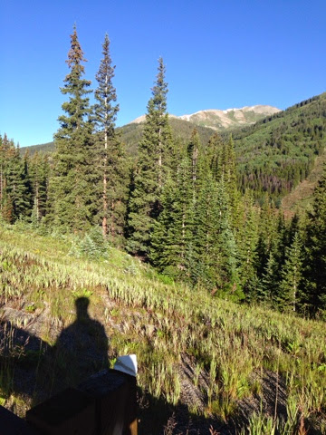
| ABOVE: My Cyclemeter at rest stop #1. I climbed 1,600 feet in the first 10 miles! BELOW: notice the snow at the mountain tops. And a shadow selfie. :) |
 |
| ABOVE: limited support for bicycle mechanic issues. BELOW: My status at rest stop #2. |


 |
| ABOVE and BELOW: Rest stop at Tennessee Pass. Mile 31. I've stashed away my wind breaker and ear warmers. |

 |
| ABOVE: the hills are alive? |
 |
| ABOVE: Doesn't show up well here, but mountain river rapids are at the bottom of the canyon after the third climb. BELOW: sunscreen provided at rest stop #3.. an alluring selfie. |


 |
| ABOVE: Rest stop #4. Climbing Vail... a rear end kicker! I caught my breath sitting on a pink thing. BELOW: The evergreens along the bike path between Vail and Copper provided gorgeous scenery during the steepest climbs-- notice several cyclists are walking up the trail. This section was near 12% incline. |

 |
| ABOVE: I was melting... so I hid my warm cycling clothes behind this big ol' rock! I retrieved them after the ride. |
 |
| ABOVE and BELOW: Finish line at Copper Mountain Resort, Cyclemeter results and lasagna dinner. Notice the biggest climb (Vail) began near mile 60. Last few miles were all down hill. |


  |
| ABOVE: For about $25, you can purchase professional pics of your ride. Here are my proofs, courtesy of Sundance Images. BELOW: I earned the jersey! |

Sunday, May 25, 2014
Tour de Meers 2014: Bison and bicycles

"... do not ride into herds of bison and longhorns that can charge you..." -- Tour de Meers disclaimer.
^ uhm, ok. I gotta try this! :)
Tour de Meers is a non-competitive benefit bicycle ride held during the Memorial Day weekend in southwestern Oklahoma.
This event is an annual fundraiser for the community of Meers VFD, and this year's ride was the 25th anniversary since debuting in 1989.
You can choose from five routes ranging from 10 to 62 miles. All distances begin and end at the fire department.
Phil Parks and I cycled the 57 miler route... it's gorgeous! This distance offers three distinct sections:
1) mountains and wildlife refuge,
2) flat lands,
3) wind farm and rocks.
Most of the climbing and all the steepest climbs (which aren't very steep) occur in the first third of the course.
This was one of the most unique rides I've done for several reasons:
- You cycle thru a wildlife refuge.
- You cycle over 4 cattle guards.
- The peaks of the Wichita Mountains provide unique scenery.
- You rest stop in Cooperton, OK which is a ghost town.
- A wind farm offers an atypical backdrop.
- Zero to little auto traffic.
The weather was perfect for cycling! Cloudy, light wind and temperatures in the upper 60s at start time. Some light rain barely developed about an hour into the ride, and it felt refreshing! Cool water on your face :)
The mass start was unusual: the two longest rides begin heading south while the shortest routes head north. This looks strange as the cyclists in the middle are pointed in opposite directions. Once this minor confusion ends, everything seems normal.
On the 57 and 62, I really like how you immediately get into the heart of the ride.
An immediate downhill in the first quarter mile accelerates you to 30mph. You zoom and twist downhill into "downtown" Meers. You cycle past the famous Meers Store.
Moderate climbing begins after that with mountain tops lining the right side of the road. You feel like you're on a volcanic Hawaiian Island when you look straight up at the peaks-- it's that pretty.
The first third of the ride is the most interesting with the mountains, rock formations, trees and wildlife preserve.
Several dozen longhorn stare you down in the preserve. They could charge you if so inclined, but they didn't seem to care.
One of the coolest things was watching bison in full gallop! No one was threatened by them.
The second section of the route turns north then east out of the preserve and into the flatlands.
The wind was light on this day. Wind would be an issue on most other days. Very few cars could be found. We zoomed along near 20mph heading north.
The scenery becomes more colorful and rocky again during the last third of the ride. You also cut thru a wind farm while bicycling past the occasional farm and ranch.
Counting our long stops (which is part of the fun!), it took Phil Parks and me about four hours to complete 57 miles. Our final moving average was 17 mph.
After the ride, Phil and me along with a few other cyclists gobbled up Meersburgers and onion rings at the Meers Store-- well worth the 30 minute wait!
Notes:
- There are many volunteers at the Meers VFD and along the course.
- Parking is actually organized! Parking attendants point you to specific spots in a grassy lot next to the fire department.
- If you ride this event, I recommend the 57 mile route as it's the prettiest. (The 62 mile route steers you along a straight highway after mile 40, while the 57 cuts thru the wind farm with rock formations and rollers.) Thanks Cary McKaughan for the tip!
- I do NOT recommend the 36 mile or shorter routes as you completely bypass the wildlife preserve and best scenery.
- I saw several dozen longhorns and two to three bison in the preserve. One of the bison was in full gallop, and he crossed the road 100 yards away! None of the livestock seemed threatened by our bright colored cycling jerseys... probably not a good idea to look like a matador...
- Volunteers are stationed near the cattle guards to warn you. Small wooden bridges overlay the cattle guards if you choose.
- Very few cars are on the course as you ride thru the wildlife preserve and sparsely traveled state highways. There is no trash. You are passed by one car every 5 minutes.
- First event in which I didn't see anyone get a flat! No bad gravel, no broken glass on the road.
- You don't actually climb any mountains, you pass along the bottom of them.
- Optional... If you choose (which some do!) you can climb Mt. Scott on your bike after you complete the ride. It's about a 1,000 foot ascent along a 3 mile trek circling up the mountain. It's not considered a part of Tour de Meers... you are on your own.
- Meers is in the country. There are no places to stop and get last minute cycling stuff.
- It took exactly 3 hours to drive to Meers from Tulsa.
Summary:
- Tour de Meers. Annual bicycle ride, last Saturday in May.
- Mass start: departs 7:30am.
- Location: about 30 min NW of Lawton (the nearest "big" town) .
- Entry: only $25!
- On site/late registration available.
- You are guaranteed an event t-shirt if you pre-register.
- Routes: from 10 miles to 62 miles.
- Best route: 57 miles.
- Difficulty: easy to moderate.
- Course type: rolling hills.
- Course markings: paint and occasional road signs.
- Car traffic: little to none!
- Roads: mostly smooth asphalt.
- Biggest climb: nothing stood out. A few long, mildly slow climbs. Steepest is about 4-6% grade.
- Total climbing/ascent: 1100 feet on the 57 miler.
- Rest stops: about every 10 miles after mile 18.
- Timing/chipping: no.
- Offered at rest stops: water, gatorade, crackers, cookies, bananas, orange juice, pickle juice, and popsicles!
- Bathrooms: one or two porta-johns per rest stop.
A huge bonus on this day was the weather: temperature was only 79 degrees by the end of the ride. Cloudy skies blocked out the heat, and the wind was fairly light by Oklahoma standards.
What could have been better? Nothing! I'll be back next year. :) George


Subscribe to:
Posts (Atom)