Showing posts with label cycling. Show all posts

Sunday, May 13, 2012

Flower Power: Great bicycle event near Muskogee


(ABOVE: Quality cycling events have quality stuff at rest stops... donuts!)

Flower Power is an annual small town bicycle ride through the beautiful terrain of far eastern Oklahoma. Based out of Three Forks Harbor on the edge of Muskogee, Oklahoma, the ride takes place the last Saturday in April. And it's kinda awesome!

Many cyclists in the Tulsa area consider Flower Power as the first big cycling event of the season.

The internet site http://www.flowerpowerbike.com/ advertises that 300-500 usually ride each year. This year's ride seemed bigger, and experienced riders told me the crowd was among the largest-- credit the nice weather forecast maybe! ;)

On-line registration cost me $30 which included a nice long-sleeve "Dry Fit" souvenir shirt.

You can "late register" on site if needed.

The Flower Power registration area was located inside a modern office-like building at the Harbor, and it offered plenty of restrooms and air conditioning. (I was able to give myself a sink-bath and change clothes after the ride.)

The 9am start time is later that most, and it's welcomed as most riders drive in from out of town. (45 minute drive from Tulsa.)


Five different ride lengths ranging from 15 miles to 100 miles are offered. The 70 miler seemed to be the most popular. I chose the 50 mile course.

The elevation ranges from 500 feet to 900 feet on the 50 miler with 1200 total feet of climbing according to www.mapmyride.com.

Rest areas are located about every 10 miles. Several ladies from a bank in Fort Gibson offered smiles and the usual rest stop goodies at the mile 20 rest stop.

All rides begin at Three Forks Harbor and make a clockwise circle north then eastward through downtown Fort Gibson then toward Hulbert and Tahlequah.

Most of the roads were very smooth by Oklahoma standards. All riders will encounter short-lived gravel patches between Fort Gibson and Okay between miles 5 to 11. Otherwise the roads are mostly smooth asphalt with little traffic... really, really nice pavement!

The signature highlight of the ride begins near mile 15. Large sweeping curves plunge 200 feet to Fort Gibson Lake Dam. You will easily reach near 40mph without pedaling.

After riding across the dam, you climb up the east side for 300 feet alongside beautiful jagged rocks and under shaded trees. This climb grades near 10%. It's challenging, but doable.

The next section is also quite enjoyable. During the next 10 miles, expect more speed with more sweeping curves and downhills that take you across low water crossings. (Make sure you ride "straight up" across the low water crossings as slippery concrete at the bottom could surprise you. The scenery is ideal with occasional tree canopies, varying shades of green colors, valleys and occasional overlooks. Vehicular traffic isn't a problem.

Though I really enjoyed the 50 miler, I would recommend choosing a different distance. The problem occurs at mid-ride as the course steers you along heavy car traffic and barely shouldered Highway 51. Any other distance avoids this 5 mile stretch between Hulbert and Tahlequah. Try the 70 miler instead!
The steepest climb of the course occurs in the last 15 miles. Nicknamed "The Wormhole", the terrain sharply rises 200 feet in two chunks along a sharp curve. My bike computer registered an 18% grade for the second section of the climb-- I had to walk my bike up the hill! The rest of the course is mostly downhill.

The last rest stop is within 5 miles of the finish, and it's a fun one. Hula dancers provide you with a flowered lei to wear the last few miles!

The last rest area also provides a nice break too as the last few miles are otherwise rather blah. You finish the course riding along the wide shoulder of westbound Highway 62/64 toward Muskogee.

Flower Power ends unceremoniously as you ride back across he starting line.

The end of ride meal back is a winner. You can spread out, wash up, and cool down back inside the Three Forks Harbor office structure. Volunteers serve up a good lunch: homemade hot dogs, chili, pickles, potato salad along with plenty of water, soda and cans of beer if you choose.

You overlook the harbor in a shaded picnic-like setting.Overall I give this ride a four star recommendation.

If you live anywhere near Tulsa, Oklahoma City, NW Arkansas, or even Dallas, this one is worth the trip.

Beautiful scenery, curves, climbs, descents, smooth roads and friendly faces. I'll be back next year!

Thanks for reading. George

Tuesday, September 20, 2011

50mph: Breaking the speed limit on a bicycle


(ABOVE: Speed limit 40mph? Ooops...)

One of the steepest paved roads that you'll find anywhere is right here within the city limits of Tulsa. I took advantage of it and zoomed to my fastest speed ever on a bicycle.


Previously, 47mph was my all-time top speed. I reached that speed three years ago on a down hill during the Tulsa Tough. I got competitive and was "being a boy" as I raced a friend. I haven't been close to that speed since.


(ABOVE: The huge hill is near mile 12 of my ride along Elwood Drive.)

Elwood Drive between 61st and 71st features a sudden downhill plunge from Turkey Mountain.
Topography maps show a short, steep 200 foot drop in less than a quarter of a mile. You very much get a "falling off the edge of the world" feeling if you drive it.

The opportunity was perfect to try Elwood hill on a quiet September morning: sunshine, no wind, and barely any traffic at 9:30am. The road is smooth and straight.

But to race to the bottom I first needed to climb to the top!

I pulled out of Turkey Mountain park and headed north toward the hill's increasing slope.

On approach the hill appeared to rise straight up. The increasing slope added weight. Each pedal stroke proved a deliberate effort. I felt like I was pulling a car with my bike. I was tempted to walk it, but I had to keep going. I would roll backward if I slowed down or tried to get off the bike!

(ABOVE: Near 5% where I'm standing the Elwood/Turkey Mountain hill rapidly increases to 20% grade for about 150 feet.)

I cranked up the hill at a walking pace in my easiest gear. The worst of the climb thankfully stretched only 0.1 miles. I wouldn't have made it much longer!

I reached the top of Elwood/Turkey Mountain with my lungs on fire. I collapsed on a giant rock to catch my breath.

I checked my GPS: near 20% grade! I smiled as I set a new personal climbing record easily surpassing my previous mark of a 15% grade. I learned that 20% is near impossible, but I made it!
For comparison, that's nearly twice as steep as Yale Avenue between 81st and 91st in South Tulsa.

Now for the fun part.

(ABOVE: Looking southward, I waited for the few cars to clear before zooming down. The edge of the hill comes quickly.)


I first double checked my bike: brakes good, wheels straight, tires clean. And helmet snug.

I waited until no cars were visible. With the road clear I positioned my bike in the middle of the road, snapped into my pedals, and pointed my front tire straight down. I released the brakes.

My bicycle rapidly accelerated without pedaling. I tucked into a ball to reduce resistance. Within seconds: 20mph, 30mph, 35mph....

I took my eyes off the speedometer to concentrate on the road.
I steered in a perfect line nearly down the center of the empty road. Completely focused and perfectly smooth and very fast.

A thunderous river of air rushed through my helmet-- try lowering your car window at freeway speed for comparison. The scenery zoomed past me at what seemed like light speed.
I whooshed past the Turkey Mountain park entrance in violation of the speed limit. I knew I was well north of 40mph.

The hill flattened, and I braked gradually at first. I glanced down at my speedometer as it dropped below 30mph. It took a while to slow down!

How fast did I go? I checked the GPS in my pocket: 49.53mph. Wow!!!

I don't plan to break this personal record again, Wifey might kill me before any bicycle would.


Thursday, July 21, 2011

Bicycling: Tour de Paris... Texas


(ABOVE: Russ McCaskey and me pose for a CORNY picture.)


KJRH news anchor Russ McCaskey approached me a few weeks back about the possibility of riding bicycles through Paris. Ahhh, wow! Imagine the views of the Eiffel Tower, the vistas and city streets of downtown Paris. The idea of carving your way thru the city's historic structures while the Tour de France is also ongoing.

Well, maybe someday I can do the above in Paris, France. But for now, you can do all of those things in Paris, Texas...with the joy of 100 degree Texas heat!

Tour de Paris is a non-competitive bicycle ride which begins and ends in Paris, TX at the civic center.

Paris is less than 3 hours away from Tulsa, and it's the closest cycling event in Texas from Tulsa.

Scheduled the third Saturday in July, the ride's timing coincides with the Tour de France ongoing overseas.

About 1,000 cyclists participate in Tour de Paris with rides ranging from 20 to 68 miles. The 30 year old event has grown into a big deal for the town: We listened to local radio promoting it while signs and banners welcomed bicyclers.

Russ and me, along with his brother Lance chose the 57 miler, one of four lengths offered.

The ride begins on the south side of Paris near Love Civic Center. After a detour to circle downtown, the ride turns southwestward making a figure 8 pattern in rural Lamar county before returning to town.

....

About our day:

Russ and I left Tulsa near 4am and arrived in Paris for breakfast before 7am. We then drove to and registered at the Civic Center. It didn't take long to register.

The staging area for each distance was well marked on the street outside the civic center. Cyclists gathered accordingly.

Tour de Paris began sharply at 8am. Drummers from the high school band pounded out rhythms along the starting line. We were sweating before we started pedaling as the morning temperature was already a warm 78 degrees.

A clean start to the ride... Our herd of bicycles steered northward toward downtown.

This was really cool.... We circled the Paris city square as the downtown district embraced the ride.

Hundreds of locals gathered in downtown to watch us on our bicycles. Folks of all ages waved little American flags, and couples smiled from their lawn chairs-- I've never seen so many folks from the "general public" come out to watch a non-competitive ride! The cheery, parade-like atmosphere made me smile too.

After circling downtown we accelerated and headed toward the country.

(BELOW PICS: After a non-heart healthy breakfast and pictures in front of the Eiffel Tower (notice the cowboy hat on the tower), the Tour de Paris begins with a tour of Paris)


We left town, trekking southwest along State Highway 19/24. For safety, the highway was narrowed so that cyclists could enjoy a wide shoulder plus one lane of traffic-- we had no issues with cars the entire route. We left the highway after several miles and cycled down Farm to Market roads. (FM roads are secondary, mostly smooth roads.) Only local traffic was allowed, so we didn't feel like we were competing with cars.

Lots of police.... state, county and city officers protected highway intersections for the entire route- that's nice to see; you don't see that on every ride!

There were a bunch of rest stops! After the ride got into the country, stops were offered about every 7-10 miles (instead of every 10-15 miles like most events).

The stops were quite welcomed too as temperatures climbed. Local scouts, civic groups and churches volunteered....extremely well supported, very impressive! A few unmanned, intermediate stops also popped up.

The course was well marked. Easy to read signs and arrows pointed where to go. Signs also marked how far you were to the next rest stop.

We saw plenty of brown grass (see pics) and dry, rocky creeks due to the drought. The FM roads across the farmland offered little to no shade. Plenty of corn though!

Our 57 mile course was generally flat with only small rises and valleys. The middle 10 miles proved the most hilly, but the steepest climb registered only 4-6% grade. The climbs I'm used to around Tulsa can be tougher than 10-12%.

The biggest downhill was just after the mile 40 rest stop. I coasted to 32 mph during the near 100 foot drop. The last half of the ride heads generally north, so a south wind provided a tail wind.
 
At the half way mark my average speed was in my comfort zone of 17mph. Wind wasn't a big deal, but the heat was brutal. The temperature read out on my bike computer climbed toward the upper 80s by 10am.

The last 15 miles were the least fun. Our speed dropped as we melted in the heat. Temperatures climbed north of 90 degrees. The black asphalt did a fabulous job of absorbing sunlight and reflecting the heat into our face... not sure I've ever sweated so much! Russ and I agreed later that this was the highest index we've ever cycled.


(BELOW: Tour de Paris tours the countryside of Lamar county in northeast Texas. Cyclists are given the entire lane to ride. Officers make sure the intersections are bicycle friendly. Plenty of smiling faces at rest stops.)


The last rest stop was at mile 50, and we remained there the longest-- we really didn't want to leave the giant box fans and portable air conditioners!

Every support person seemed to enjoy the cycling atmosphere despite the heat. You could load up with plenty of ice, water, sports drinks and homemade snacks.

We continued to slow down (about 12-13 mph) during the last miles. Visible, rising thermals created wavy lines in our vision. It felt like riding across a fire pit! My on-board thermometer peaked at 108°! The temperature fluctuated as much as 10° depending on the color of the pavement.

We were briefly confused in the last miles as you are directed the "wrong way" (see below pic) on the shoulder. We rode back into town on Highway 19/24 going north in the southbound shoulder. Police and pylons kept cars separated from the bikes. This was done to prevent you from crossing the 75mph highway twice within a few miles. 

We finished the ride after nearly four hours. Cheerleaders from Paris High School celebrated and high-fived us at the finish line. Portable, outdoor, overhead sprinklers cooled us down in the civic center parking lot. Lance, Russ and me just stood there in the cool mist... we didn't want to leave!
 
The civic center offered a free lunch with smoothies after the ride. We enjoyed the air conditioning and gobbled up homemade burgers.

....

Overall, I give the Tour de Paris four out of five stars. The only demotion is that the generally flat terrain and open farmland isn't the most exciting. But overall, it's certainly more scenic than  "Hotter than Hell" in Wichita Falls.

Lets change the rating to a 4.5. The superb support, safety, smooth roads and smiling faces go along way-- I'll be back again. :)

Thanks for reading, George.

SUMMARY:

Event: Tour de Paris

When: third Saturday in July

Where: Paris, TX at Love Civic Center

Time: Mass start at 8am

Registration: on-line or on-site

Late registration: $35 (in 2011)

Course: mostly easy... flat course to easy rolling hills

Biggest climb: 100ft

Steepest climb: only 4-5%

Terrain: farmland, corn! very little shade

Timing/chipping/numbers: no timing. You wear numbers.

Restrooms: at Civic center for begin/end of ride. Porta-johns at rest stops.

You get: event t-shirt

Support: little provided-- change your own flat. Richardson BikeMart van was seen for big repairs.

Rest stops: very well supported! Pickle juice, fruit, homemade goodies. Water, sports drinks. Lots of volunteers Box fans to cool you down! Portable A/C at the last rest stops!

Traffic: no issues. Few to no cars on route. Local traffic only on FM roads.

End of ride: All you can eat burgers inside the air conditioned civic center.

Favorite things about the ride: high school band at starting line, circling downtown Paris in front of a crowd, the awesome rest stops with portable A/C, well marked course with police and sprinklers at end of ride.

 [On a unrelated personal note I remember Paris from years ago. Their high school defeated my high school (West Orange-Stark) in football for the 4A State Championship in 1988. I had a college friend named Jason Stephens who played for Paris, and he reminded me several times who won! (This is your Jason who played 3B for the Texas A&M baseball team if any Paris area folks are reading this.]

(BELOW: I've never seen dry creeks this far east. My thermometer registers 105° off the pavement at high Noon. Highway 19/24 is protected for cyclists. At the finish line, Lance, Russ and myself cooling down!)


(BELOW: Pickle juice!, An Aggie refusing shade under a Longhorn tent, and Russ McCaskey felt like death.)


Monday, March 28, 2011

Bicycling: "Beauty and the Beast" near Tyler, 2011

(ABOVE: The beautiful pine trees of East Texas provide shade for much of the ride.)

"Beauty and the Beast" is an annual bicycle ride in Tyler, TX during late March. I signed up for the event last year, but I ended up missing it as I stayed in Tulsa to work during a big Spring snow storm.

I've wanted to do this ride for years as Tyler is my mother's family headquarters: I have two aunts, a cousin and their families living there. My grandparents enjoyed a beautiful home on well-known Cumberland Road. My Mother grew up near Tyler in the small town of London, TX. The community of Carlisle was renamed Price, TX for my great-grandfather J.M. Price. For the ride this year, I stayed with my Aunt Marcia and my Mother drove in from Orange to see me. :)

The weather this year was great for cycling: near 70 warming to low 80s by the end of the ride, not overly humid, and a south breeze of 15mph. Morning clouds helped too.

How was the ride? Awesome-- I was extremely impressed! The event appeared to be exceptionally well managed, especially for a smaller town ride.

Here are the details:

About 700 cyclists signed up to ride distances ranging from 22 to 67 miles. The course is rarely flat...lots of rollers. (Rollers are rolling hills offering gentle climbs and fun descents. Most cyclists love them!) It appeared that the 53 and 67 mile courses were most popular. I debated whether to ride the 67 miler, but my group of three cyclists chose the 53, so I stayed with them. I chose having fun rather than stretching my endurance!

The terrain varied from an elevation of 350ft to as high as about 550ft. The best part: the roads were smooth and free of debris: no rocks, sand or glass. I didn't see even a single pebble loose on the road as the course appeared to have been swept-- this was the cleaned course I have ever cycled. Very few folks had flats. Most surfaces were asphalt with minor road patches-- a very comfortable ride.

The well-marked course had lots of smiling volunteers. I was surprised to see that US Highway 69 was temporarily closed to allow us maximum safety. Traffic was reduced on the FM, county and state highways for the rest of the ride-- I never felt unsafe. Every major intersection had DPS (highway police officers) and volunteers making sure that regular auto traffic was cleared for bicycles.

Rest areas were located every 10 miles and offered shade, plenty of restrooms, snack fuel, water and sports drinks to keep you going.

And the ride was beautiful! The "beauty" lived up to its name with pine trees, wildflowers and scenic hills, farms and well-kept properties.

Regardless of which distance you choose to ride, the biggest hill (the "Beast") is during the last 5 miles. For experienced riders, the Beast isn't difficult. Some may choose to walk their bike up the 200 ft Beast which is near 0.25 miles long at 11% grade (according to my bike computer).

The ride ended a few miles later back where you started from at K.E. Bushman's Winery and Celebration Center. The huge, modern facility offered a festive indoor, upper scale atmosphere. A spaghetti and wine dinner greeted the finishers. Inside, they even provided towels for you to wipe your sweat after your ride!

Overall, I give "Beauty and the Beast" 4.5 out 5 stars. The only improvements I can think of: 1) Timer chips would be nice. It's fun to see how your time compares with other riders. 2) The ride ends without fanfare. Not that it's important, but some type of finish line, perhaps with a giant timer clock, would be cool.

If you are looking for smooth roads, curves, hills, trees, wildflowers along a safe route, you need to try "Beauty and the Beast"-- I'll be back next year! George
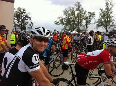

(BELOW: My Mother and I. She drove to Tyler to watch me ride. Yay!)


(ABOVE: Lots of friendly folks clustered at K.E. Bushman's Winery for the start. BELOW: I rode at about 90% of my capacity for the first hour of the ride. A respectable 19mph average.)


(ABOVE: This rest stop in Troup, TX provided a brief cool down. BELOW: You are rewarded with sunlit, wildflower covered fields when you pedal out from the pines.)

(ABOVE: With my sightseeing and the hills, my average speed dropped to 17.2mph. BELOW: Just before the "Beast", friendly folks cheer you along your way.)


(ABOVE: This is the biggest hill. The 1/4 mile climb of the Beast doesn't last very long, but it's a steep 11% grade according to my bike computer. I rode 6mph. BELOW: My average speed dipped to 16mph after the Beast. I sprinted at about 25mph for the last miles after the hill to get my average pace back to 17mph.)