
 (ABOVE: Obligatory tough-guy look. I guess I'm trying to look fearless or something.)
Chasers: Carson Brett, Shawn Brett, Carol Bush, George & Shyla Flickinger
Below are images from our Northwest Oklahoma storm chase on April 14, 2012. Two video clips and one still image were picked up by the NBC Evening News, so Mom was impressed!
Most of these pictures were taken by Shawn Brett, and the series tells the story:


(ABOVE: Our prelim chase target is Woodward, OK. We drive 200 miles west, and a Tornado Warned storm develops. No tornado yet, but plenty of hail.
BELOW: We chase the storm toward Alva. Decided to leave this storm as a stronger, more dominant cell intensifies near Moreland. Instead of chasing it, we drive ahead of the storm and wait for it to come to us.)


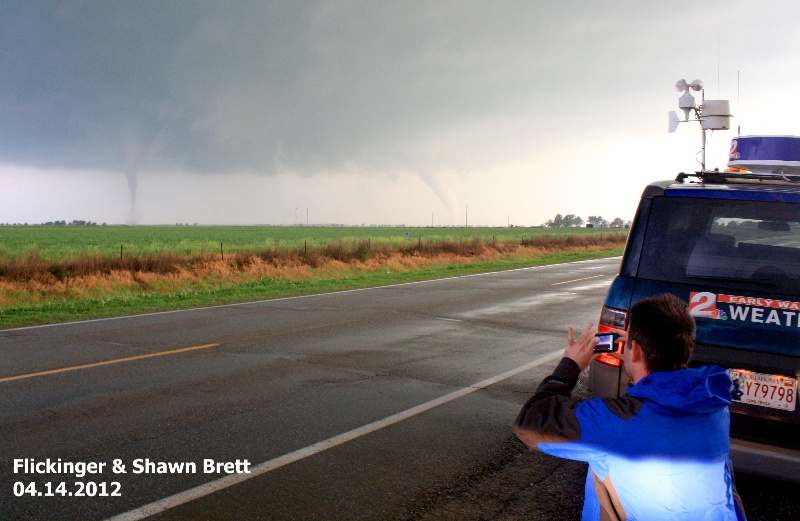
(ABOVE: After producing a large tornado near Moreland we wait along Highway 64. Looking southward, we watch another tornado develop and strengthen into a "small" cone shape.
BELOW: Supercells can spawn more than one tornado. New tornadoes can sprout on the southeast side of an existing tornado in a classic structured storm. These twin tornadoes are about 2-3 miles apart.)


(ABOVE: The rope-out tornado phase. The tube stretches, and its shape becomes more dominated by the prevailing south wind and the storm's own local wind. The wind is stronger above the ground, so the tube stretches before being pulled back into the storm. This tornado's life cycle= 20 minutes.
BELOW: We determine that we are "fine" as we are safe from the second tornado. From our view it's tracking from right to left (just east) of our location. For a few minutes we are between the two tornadoes! No panic at all, we are in a good position and have road options if needed.)


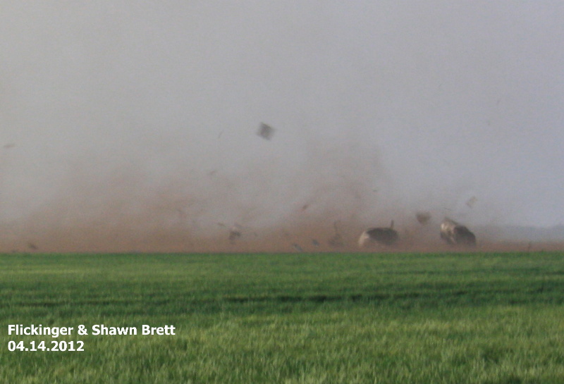
(ABOVE: This is smallish tornado, probably of EF1 intensity. It gracefully tracks across the field and heads toward a barn.
BELOW: You are looking inside the tornado from less than a half-mile away. The visible condensation cloud around the tornado isn't very visible at close range. The south wind is the strongest in a classic tornado. The barn rips apart and debris screams northward before wrapping up into the circulation.)


(ABOVE: The tornado continues moving NE as we drive through the tornado debris field. We then turn northward and watch it cross the road in front of us.
BELOW: The RFD is the rear flank downdraft wind of a tornadic storm. It's a very, very strong west wind which could reach near 100mph. The RFD occurs south of a tornado. Notice the power lines bending over in the wind. We position Storm Chaser 2 to "face the wind" to reduce our profile.)


(ABOVE: my wife and chase partner, Shyla takes video of the tornado as we ride out the RFD.)

ABOVE: We decide to end our chase on a dirt road at sunset-- I don't chase after dark.
From this vantage point we looked northward as two more tornadoes developed (not pictured... too dark). Typical of long track supercells, the storm continued dropping tornadoes as it moved into Kansas. This storm produced a tornado in Wichita two hours later.)
Absolutely remarkable George. WOW!
ReplyDeleteamazing chase!!! you have some brave bones!!!
ReplyDelete